Nothing
README.md
In foster: Forest Structure Extrapolation with R
FOSTER: Forest structure extrapolation with R

The goal of foster is to streamline the modeling of the relationship
between satellite imagery time series or any other environmental
information, such as terrain elevation, with forest structural
attributes derived from 3D point cloud data and their subsequent
imputation over the broader landscape.
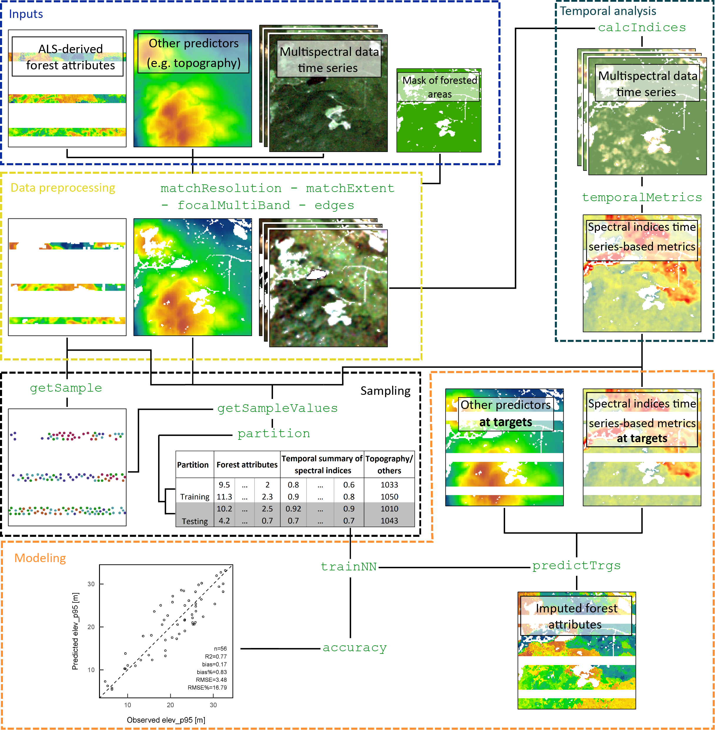
The package is organized around functions for data preprocessing,
stratified random sample selection, spectral index calculation, time
series summary metrics calculation, k-NN predictive model development
and their accuracy assessment, and finally response variable
(i.e. forest attributes) imputation. The following figure shows a
diagram explaining the general processing flow a user might encounter
when imputing forest attributes from selected predictors that may
include time series of multispectral satellite images and topographic
variables.
Installation
You can install the development version of foster from
GitHub with:
# install.packages("devtools")
devtools::install_github("mqueinnec/foster")
Get Started
A vignette is available to give an overview of FOSTER and run through an
example of ALS metrics imputation.
browseVignettes("foster")
Note that if using the development version of FOSTER, the vignette to be
build during installation to access it with browseVignette("foster").
It will take a few minutes to build the vignette.
devtools::install_github("mqueinnec/foster", build_vignettes = TRUE)
Try the foster package in your browser
Any scripts or data that you put into this service are public.
foster documentation built on March 30, 2021, 5:11 p.m.
R Package Documentation
Browse R Packages
We want your feedback!
Note that we can't provide technical support on individual packages. You should contact the package authors for that.
FOSTER: Forest structure extrapolation with R
The goal of foster is to streamline the modeling of the relationship between satellite imagery time series or any other environmental information, such as terrain elevation, with forest structural attributes derived from 3D point cloud data and their subsequent imputation over the broader landscape.
The package is organized around functions for data preprocessing, stratified random sample selection, spectral index calculation, time series summary metrics calculation, k-NN predictive model development and their accuracy assessment, and finally response variable (i.e. forest attributes) imputation. The following figure shows a diagram explaining the general processing flow a user might encounter when imputing forest attributes from selected predictors that may include time series of multispectral satellite images and topographic variables.
Installation
You can install the development version of foster from GitHub with:
# install.packages("devtools")
devtools::install_github("mqueinnec/foster")
Get Started
A vignette is available to give an overview of FOSTER and run through an example of ALS metrics imputation.
browseVignettes("foster")
Note that if using the development version of FOSTER, the vignette to be
build during installation to access it with browseVignette("foster").
It will take a few minutes to build the vignette.
devtools::install_github("mqueinnec/foster", build_vignettes = TRUE)
Try the foster package in your browser
Any scripts or data that you put into this service are public.
R Package Documentation
Browse R Packages
We want your feedback!
Note that we can't provide technical support on individual packages. You should contact the package authors for that.
Embedding an R snippet on your website
Add the following code to your website.
For more information on customizing the embed code, read Embedding Snippets.