Reference.md
In harryprince/geospark: Bring Local Sf to Spark
PostGIS vs ESRI UDF vs SF vs Geospark
Geometry Constructure
Complex geometries / trajectories: point, polygon, linestring, multi-point, multi-polygon, multi-linestring, GeometryCollection
postgis|esri udf|sf|geospark|function| definition
---|---|---|---|---|---
partial|partial|yes|no|st_cast| Convert the geometry type from one to another
yes|yes|yes|yes|ST_GeomFromText | Return a specified ST_Geometry value from Well-Known Text representation (WKT).
yes|yes|no|no|ST_MakeBox2D | Creates a BOX2D defined by the given point geometries.
yes|yes|yes|yes|ST_Point | Returns an ST_Point with the given coordinate values. OGC alias for ST_MakePoint.
yes|no|no|no|ST_PointFromGeoHash | Return a point from a GeoHash string.
yes|yes|yes|yes|ST_Polygon | Returns a polygon built from the specified linestring and SRID.
yes|yes|yes|yes|ST_Transform| Coordinate Reference System / Spatial Reference System Transformation: for exmaple, from WGS84 (EPSG:4326, degree-based), to EPSG:3857 (meter-based)
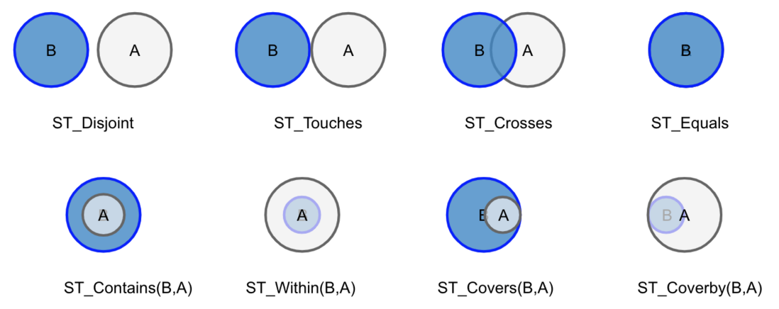
Geometry Relation
Data IO
CSV, TSV, WKT, WKB, GeoJSON, NASA NetCDF/HDF, Shapefile (.shp, .shx, .dbf)
Spatial Query
range query, range join query, distance join query, K Nearest Neighbor query
Spatial Index
R-Tree, Quad-Tree
Spatial partitioning
KDB-Tree, Quad-Tree, R-Tree, Voronoi diagram, Hilbert curve, Uniform grids
Geometry Measurement
postgis|esri udf|sf|geospark|function| definition
yes|yes|yes|yes|ST_Length| calculate line length
yes|yes|yes|yes|ST_Area| calculate polygon area
Geometry Advanced Operations
ST_Distance
ST_ConvexHull
ST_Envelope
ST_Centroid
ST_PrecisionReduce
ST_IsSimple
ST_Buffer
ST_AsText
References
harryprince/geospark documentation built on Dec. 26, 2021, 5:30 a.m.
R Package Documentation
Browse R Packages
We want your feedback!
Note that we can't provide technical support on individual packages. You should contact the package authors for that.
PostGIS vs ESRI UDF vs SF vs Geospark
Geometry Constructure
Complex geometries / trajectories: point, polygon, linestring, multi-point, multi-polygon, multi-linestring, GeometryCollection
postgis|esri udf|sf|geospark|function| definition ---|---|---|---|---|--- partial|partial|yes|no|st_cast| Convert the geometry type from one to another yes|yes|yes|yes|ST_GeomFromText | Return a specified ST_Geometry value from Well-Known Text representation (WKT). yes|yes|no|no|ST_MakeBox2D | Creates a BOX2D defined by the given point geometries. yes|yes|yes|yes|ST_Point | Returns an ST_Point with the given coordinate values. OGC alias for ST_MakePoint. yes|no|no|no|ST_PointFromGeoHash | Return a point from a GeoHash string. yes|yes|yes|yes|ST_Polygon | Returns a polygon built from the specified linestring and SRID. yes|yes|yes|yes|ST_Transform| Coordinate Reference System / Spatial Reference System Transformation: for exmaple, from WGS84 (EPSG:4326, degree-based), to EPSG:3857 (meter-based)
Geometry Relation
Data IO
CSV, TSV, WKT, WKB, GeoJSON, NASA NetCDF/HDF, Shapefile (.shp, .shx, .dbf)
Spatial Query
range query, range join query, distance join query, K Nearest Neighbor query
Spatial Index
R-Tree, Quad-Tree
Spatial partitioning
KDB-Tree, Quad-Tree, R-Tree, Voronoi diagram, Hilbert curve, Uniform grids
Geometry Measurement
postgis|esri udf|sf|geospark|function| definition yes|yes|yes|yes|ST_Length| calculate line length yes|yes|yes|yes|ST_Area| calculate polygon area
Geometry Advanced Operations
ST_Distance ST_ConvexHull ST_Envelope ST_Centroid ST_PrecisionReduce ST_IsSimple ST_Buffer ST_AsText
References
R Package Documentation
Browse R Packages
We want your feedback!
Note that we can't provide technical support on individual packages. You should contact the package authors for that.
Embedding an R snippet on your website
Add the following code to your website.
For more information on customizing the embed code, read Embedding Snippets.