In nickmckay/compositeR: A Package to Create Paleoclimate Composite Records
knitr::opts_chunk$set(
  collapse = TRUE,
  comment = "#>",
  knitr.graphics.rel_path = FALSE
)
library(compositeR)
library(lipdR)
library(geoChronR)
library(ggplot2)
library(dplyr)
library(tidyr)
library(purrr)
FD <- lipdR::readLipd("http://lipdverse.org/geoChronR-examples/arc2k/Arctic2k.zip")

FDts <- as.lipdTsTibble(FD)
Create a grid
# Define the boundaries of your grid
min_lat <- 60
max_lat <- 80
min_lon <- -80
max_lon <- 30

# Define the resolution of your grid (in degrees)
resolution <- 10

# Create sequences for latitude and longitude
lats <- seq(min_lat, max_lat, by = resolution)
lons <- seq(min_lon, max_lon, by = resolution)

# Get the lat/lon edges too
latEdges <- seq(min_lat - resolution/2, max_lat + resolution/2, by = resolution)
lonEdges <- seq(min_lon - resolution/2, max_lon + resolution/2, by = resolution)

# Create a grid from these sequences
grid <- expand.grid(lon = lons,lat = lats)

# View the first few rows of the grid
head(grid)

# Plot the grid on a map
sites <- mapLipd(FD,size = 3) +
  geom_hline(yintercept = latEdges, color = "grey80") +
  geom_vline(xintercept = lonEdges, color = "grey80") +
  geom_point(data = grid, aes(x = lon, y = lat),color = "blue")

sites
note that the grid df is grid centers, while the edges are the boundaries of each gridcell
Find the nearest grid point for each dataset
#calculate all the distances between the datasets and each grid cell
allDistances <- map2(FDts$geo_longitude,FDts$geo_latitude,\(x,y) geosphere::distHaversine(c(x,y),as.matrix(grid)))

#find the minimum, and add into the tibble
FDts$cell <- map_dbl(allDistances,which.min)


#make another map to show the number of datasets in each cell
nPerCell <- FDts |>
  select(dataSetName,cell) |>
  distinct() |>
  group_by(cell) |>
  summarize(count = n())


grid$count <- 0 #initialize with zero
grid$count[nPerCell$cell] <- nPerCell$count


baseMap(grid$lon,grid$lat) +
  geom_tile(data = grid,aes(x = lon, y = lat, fill = count),alpha = .5,color = "black") +
  geom_point(data = FDts,aes(x = geo_longitude, y = geo_latitude),colour = "blue",size = 3) +
  scale_fill_viridis_b(right = FALSE)
Now, to actually composite these data
Let's filter the timeseries data down to one value per site.
toComp <- FDts |>
  filter(interpretation1_variable == "T") #select only temperature sensitive timeseries

#now let's use compositeR to create a function that will composite 2 or more datasets within a cell

ourCompositer <- function(cellnum,toComp,binvec){

  thisTS <- filter(toComp,cell == cellnum)

  if(nrow(thisTS) == 0){
    ensOut <- list(ages = rowMeans(cbind(binvec[-1],binvec[-length(binvec)])))

    ensOut$composite <- ensOut$proxyVals <- ensOut$proxyUsed <- matrix(NA, nrow = length(ensOut$ages))

    return(ensOut)

  }else{

  tc <- as.lipdTs(thisTS) |> splitInterpretationByScope()
  ensOut <- compositeEnsembles2(tc,
                                binvec=binvec,
                                ageVar = "year",
                                binFun=sampleEnsembleThenBinTs,
                                stanFun=standardizeOverRandomInterval,
                                normalizeVariance=TRUE,
                                gaussianizeInput = TRUE,
                                nens=100,
                                duration = 200,
                                searchRange=c(1200,2000),
                                minN=5,
                                scale = TRUE #scale composite to mean = 0, sd = 1 after compositing
                              )
  return(ensOut)
  }
}

grid$cell <- seq_along(grid$lat) #number the grid cells
allComps <- map(grid$cell,.f = ourCompositer,toComp = toComp,binvec = seq(0,2000,by = 10))

grid$composites <- allComps

extractMedians <- function(x){
  if(ncol(x$composite) == 1){
    return(tibble(year = x$ages,composite = x$composite))
  }else{
    return(tibble(year = x$ages,composite = apply(x$composite,1,median, na.rm = TRUE)))
  }

}

#pull the medians out of the ensembles
grid$compMedians <- map(allComps,extractMedians)
grid$compMat <- map(allComps,\(x) x$composite)
Now let's calculate some spatially weighted composites
toCombine <- filter(grid,map_lgl(compMat,\(x) !(all(is.na(x)))))

toCombine$weights <- pracma::cosd(toCombine$lat)
toCombine$weights <- toCombine$weights / sum(toCombine$weights)

toCombine$weightedMat <- map2(toCombine$compMat,toCombine$weights,\(x,y) x*y)

weightedArray <- array(unlist(toCombine$weightedMat),dim = c(nrow(toCombine$weightedMat[[1]]),ncol(toCombine$weightedMat[[1]]),length(toCombine)))

meanArray <- apply(weightedArray,c(1,2),sum,na.rm = TRUE)

plotTimeseriesEnsRibbons(X = toCombine$composites[[1]]$ages,Y = meanArray) +
  scale_x_continuous(breaks = seq(0,2000,by = 100)) +
  labs(x = "Year AD", y = "Area weighted composite",title = "Area Weighted Composite")
Make some maps of the composites!
#tidy up the data frame for mapping
spatialMedians <- grid |>
  select(-composites) |>
  unnest(compMedians)


#Pick a year to map:
toMap <- filter(spatialMedians,year == 1905)


baseMap(toMap$lon,toMap$lat,f = .2) +
  geom_tile(data = toMap,aes(x = lon, y = lat, fill = composite),alpha = .5,color = "black") +
  scale_fill_distiller(palette = "RdBu",limit = max(abs(toMap$composite),na.rm = TRUE) * c(-1, 1))
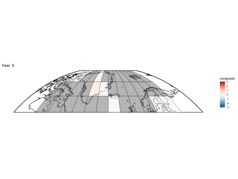
Now can we animate it?
library(gganimate)

bm <- baseMap(grid$lon,lat = grid$lat,f = .2)

anim <- bm +
  geom_tile(data = spatialMedians,aes(x = lon, y = lat, fill = composite),alpha = .5,color = "black") +
  scale_fill_distiller(palette = "RdBu",limit = max(abs(toMap$composite),na.rm = TRUE) * c(-1, 1)) +
  labs(title = 'Year: {frame_time}', x = 'GDP per capita', y = 'life expectancy') +
  transition_time(year)

animate(anim,fps = 4,nframes = length(unique(spatialMedians$year)))
nickmckay/compositeR documentation built on Aug. 16, 2024, 5:37 p.m.
R Package Documentation
Browse R Packages
We want your feedback!
Note that we can't provide technical support on individual packages. You should contact the package authors for that.
knitr::opts_chunk$set( collapse = TRUE, comment = "#>", knitr.graphics.rel_path = FALSE )
library(compositeR) library(lipdR) library(geoChronR) library(ggplot2) library(dplyr) library(tidyr) library(purrr)
FD <- lipdR::readLipd("http://lipdverse.org/geoChronR-examples/arc2k/Arctic2k.zip") FDts <- as.lipdTsTibble(FD)
Create a grid
# Define the boundaries of your grid min_lat <- 60 max_lat <- 80 min_lon <- -80 max_lon <- 30 # Define the resolution of your grid (in degrees) resolution <- 10 # Create sequences for latitude and longitude lats <- seq(min_lat, max_lat, by = resolution) lons <- seq(min_lon, max_lon, by = resolution) # Get the lat/lon edges too latEdges <- seq(min_lat - resolution/2, max_lat + resolution/2, by = resolution) lonEdges <- seq(min_lon - resolution/2, max_lon + resolution/2, by = resolution) # Create a grid from these sequences grid <- expand.grid(lon = lons,lat = lats) # View the first few rows of the grid head(grid) # Plot the grid on a map sites <- mapLipd(FD,size = 3) + geom_hline(yintercept = latEdges, color = "grey80") + geom_vline(xintercept = lonEdges, color = "grey80") + geom_point(data = grid, aes(x = lon, y = lat),color = "blue") sites
note that the grid df is grid centers, while the edges are the boundaries of each gridcell
Find the nearest grid point for each dataset
#calculate all the distances between the datasets and each grid cell allDistances <- map2(FDts$geo_longitude,FDts$geo_latitude,\(x,y) geosphere::distHaversine(c(x,y),as.matrix(grid))) #find the minimum, and add into the tibble FDts$cell <- map_dbl(allDistances,which.min) #make another map to show the number of datasets in each cell nPerCell <- FDts |> select(dataSetName,cell) |> distinct() |> group_by(cell) |> summarize(count = n()) grid$count <- 0 #initialize with zero grid$count[nPerCell$cell] <- nPerCell$count baseMap(grid$lon,grid$lat) + geom_tile(data = grid,aes(x = lon, y = lat, fill = count),alpha = .5,color = "black") + geom_point(data = FDts,aes(x = geo_longitude, y = geo_latitude),colour = "blue",size = 3) + scale_fill_viridis_b(right = FALSE)
Now, to actually composite these data
Let's filter the timeseries data down to one value per site.
toComp <- FDts |> filter(interpretation1_variable == "T") #select only temperature sensitive timeseries #now let's use compositeR to create a function that will composite 2 or more datasets within a cell ourCompositer <- function(cellnum,toComp,binvec){ thisTS <- filter(toComp,cell == cellnum) if(nrow(thisTS) == 0){ ensOut <- list(ages = rowMeans(cbind(binvec[-1],binvec[-length(binvec)]))) ensOut$composite <- ensOut$proxyVals <- ensOut$proxyUsed <- matrix(NA, nrow = length(ensOut$ages)) return(ensOut) }else{ tc <- as.lipdTs(thisTS) |> splitInterpretationByScope() ensOut <- compositeEnsembles2(tc, binvec=binvec, ageVar = "year", binFun=sampleEnsembleThenBinTs, stanFun=standardizeOverRandomInterval, normalizeVariance=TRUE, gaussianizeInput = TRUE, nens=100, duration = 200, searchRange=c(1200,2000), minN=5, scale = TRUE #scale composite to mean = 0, sd = 1 after compositing ) return(ensOut) } } grid$cell <- seq_along(grid$lat) #number the grid cells allComps <- map(grid$cell,.f = ourCompositer,toComp = toComp,binvec = seq(0,2000,by = 10)) grid$composites <- allComps extractMedians <- function(x){ if(ncol(x$composite) == 1){ return(tibble(year = x$ages,composite = x$composite)) }else{ return(tibble(year = x$ages,composite = apply(x$composite,1,median, na.rm = TRUE))) } } #pull the medians out of the ensembles grid$compMedians <- map(allComps,extractMedians) grid$compMat <- map(allComps,\(x) x$composite)
Now let's calculate some spatially weighted composites
toCombine <- filter(grid,map_lgl(compMat,\(x) !(all(is.na(x))))) toCombine$weights <- pracma::cosd(toCombine$lat) toCombine$weights <- toCombine$weights / sum(toCombine$weights) toCombine$weightedMat <- map2(toCombine$compMat,toCombine$weights,\(x,y) x*y) weightedArray <- array(unlist(toCombine$weightedMat),dim = c(nrow(toCombine$weightedMat[[1]]),ncol(toCombine$weightedMat[[1]]),length(toCombine))) meanArray <- apply(weightedArray,c(1,2),sum,na.rm = TRUE) plotTimeseriesEnsRibbons(X = toCombine$composites[[1]]$ages,Y = meanArray) + scale_x_continuous(breaks = seq(0,2000,by = 100)) + labs(x = "Year AD", y = "Area weighted composite",title = "Area Weighted Composite")
Make some maps of the composites!
#tidy up the data frame for mapping spatialMedians <- grid |> select(-composites) |> unnest(compMedians) #Pick a year to map: toMap <- filter(spatialMedians,year == 1905) baseMap(toMap$lon,toMap$lat,f = .2) + geom_tile(data = toMap,aes(x = lon, y = lat, fill = composite),alpha = .5,color = "black") + scale_fill_distiller(palette = "RdBu",limit = max(abs(toMap$composite),na.rm = TRUE) * c(-1, 1))
Now can we animate it?
library(gganimate) bm <- baseMap(grid$lon,lat = grid$lat,f = .2) anim <- bm + geom_tile(data = spatialMedians,aes(x = lon, y = lat, fill = composite),alpha = .5,color = "black") + scale_fill_distiller(palette = "RdBu",limit = max(abs(toMap$composite),na.rm = TRUE) * c(-1, 1)) + labs(title = 'Year: {frame_time}', x = 'GDP per capita', y = 'life expectancy') + transition_time(year) animate(anim,fps = 4,nframes = length(unique(spatialMedians$year)))
R Package Documentation
Browse R Packages
We want your feedback!
Note that we can't provide technical support on individual packages. You should contact the package authors for that.
Embedding an R snippet on your website
Add the following code to your website.
For more information on customizing the embed code, read Embedding Snippets.